

Specific Objectives
By the end of the topic the learner should be able to:
- Define the great and small circles in relation to a sphere (including the Earth);
- Establish the relationship between the radii of small and great circles;
- Locate a place on the earth’s surface in terms of latitude and longitude;
- Calculate the distance between two points along the great circles and small circles (longitude and latitude) in nautical miles (nm) and kilometers (km);
- Calculate time in relation to longitudes;
- Calculate speed in knots and kilometers per hour.
Content
- Latitude and longitude (great and small circles)
- The Equator and Greenwich Meridian
- Radii of small and great circles
- Position of a place on the surface of the earth
- Distance between two points along the small and great circles in nautical miles and kilometers
- Distance in nautical miles and kilometres along a circle of latitude
- Time and longitude
- Speed in knots and Kilometres per hour.
Introduction
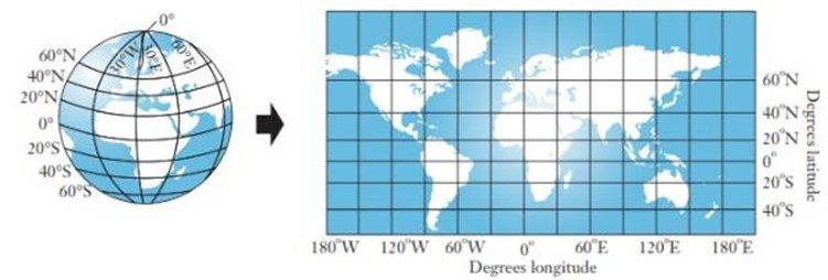
Just as we use a coordinate system to locate points on a number plane, so we use latitude and longitude to locate points on the earth’s surface.
Because the Earth is a sphere, we use a special grid of lines that run across and down a sphere. The diagrams below show this grid on a world globe and a flat world map.

Great and Small Circles
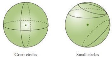
If you cut a ‘slice’ through a sphere, its shape is a circle. A slice through the centre of a sphere is called a great circle, and its radius is the same as that of the sphere. Any other slice is called a small circle, because its radius is smaller than that of a great circle. Hence great circles divide the sphere into two equal parts.
Latitude
Latitudes are imaginary lines that run around the earth and their planes are perpendicular to the axis of the earth. The equator is the latitude that divides the earth into two equal parts. It is the only great circle among the latitudes. The equator is 0°.
The angle of latitude is the angle the latitude makes with the Equator at the centre, O, of the Earth. The diagram shows the 50°N parallel of latitude. Parallels of latitude range from 90°N (North Pole) to 90°S (South Pole).

The angle θ subtended at the centre of the earth is the latitude of the circle passing through θ north of the equator. The maximum angle of latitude is 90° north or south of the equator.
Longitudes / Meridians
They are circles passing through the north and south poles.
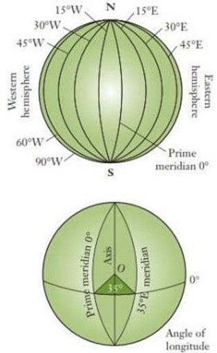
They can also be said to be imaginary semicircles that run down the Earth. They are ‘half’ great circles that meet at the North and South Poles. The main meridian of longitude is the prime meridian, 0°. It is also called the Greenwich meridian since it runs through the Royal Observatory at Greenwich in London, England. The other meridians are measured in degrees east or west of the prime meridian.
The angle of longitude is the angle the meridian makes with the prime meridian at the centre, O, of the Earth. The diagram shows the 35°E meridian of longitude.
Meridians of longitude range from 180°E to 180°W. 180°E and 180°W are actually the same meridian, on the opposite side of the Earth to the prime meridian. It runs through the Pacific Ocean, east of Fiji.
Note
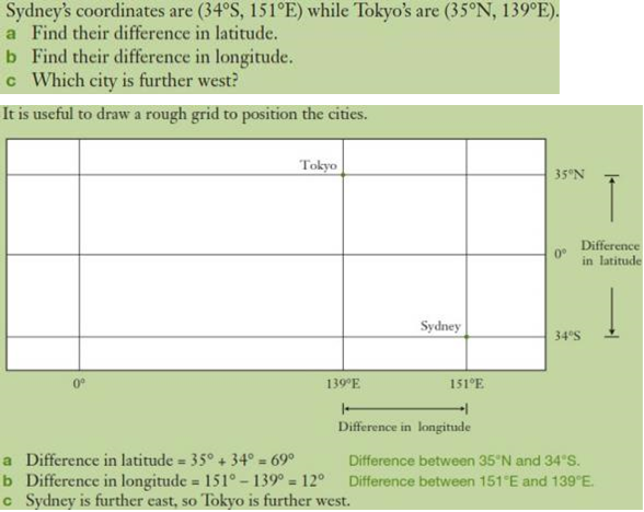
- If P is north of the equator and Q is south of the equator, then the difference in latitude between them is given by |latitude of P| + |latitude of Q|.
- If P and Q are on the same side of the equator, then the difference in latitude is the absolute difference of their latitudes.
Position Coordinates
Locations on the Earth are described using latitude (°N or °S) and longitude (°E or °W) in that order. For example, Nairobi has coordinates (1°S, 37°E), meaning its position is 1° south of the Equator and 37° east of the prime meridian.
EG
Great Circle Distances
Remember the arc length of a circle is  where θ is the degrees of the central angle, and the radius of the earth is approximately 6370 km.
On a flat surface, the shortest distance between two points is a straight line. Since the Earth’s surface is curved, the shortest distance between A and B is the arc length AB of the great circle that passes through A and B. This is called the great circle distance and the size of angle ∠AOB where O is the centre of the Earth is called the angular distance.
Note
- The length of an arc of a great circle subtending an angle of one minute at the centre of the earth is 1 nautical mile (nm).
- A nautical mile is the standard international unit for measuring distances travelled by ships and aeroplanes. 1 nautical mile (nm) = 1.853 km.
If an arc of a great circle subtends an angle θ at the centre of the earth, the arc’s length is θ nautical miles.
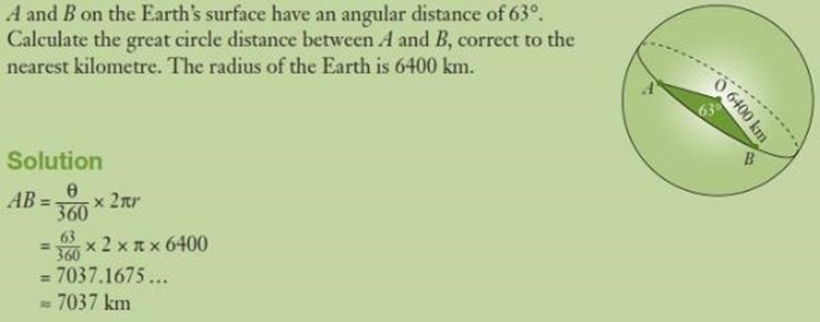
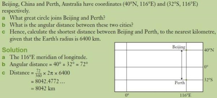
Example
Find the distance between points P and Q and express it in:
- Nm
- Km
Solution
- Angle subtended at the centre is θ. It is subtended by 60 nm. It is subtended by 60 × 60.5 = 3630 nm.
- The radius of the earth is 6370 km. Therefore, the circumference of the earth along a great circle is 2π × 6370 km.
Angle between the points is θ. Therefore, we find the length of an arc of a circle which subtends an angle θ at the centre is subtended by an arc whose length is s.
Therefore, 60° is subtended by s.
Example
Find the distance between points A and B and express it in:
- Nm
- Km
Solution
- The two points lie on the equator, which is a great circle. Therefore, we are calculating distance along a great circle. Angle between points A and B is θ.
- Distance in km = s.
Distance along a small Circle (circle of latitude)
The figure below shows ABC as a small circle, centre X and radius r cm. PQST is a great circle, centre O, radius R cm. The angle θ is between the two radii.
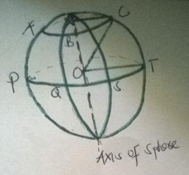
From the figure, XC is parallel to OT. Therefore, angle COT = angle XCO = θ. Angle CXO = 90° (Radius XC is perpendicular to the axis of sphere).
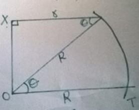
Thus, from the right-angled triangle OXC:
r = R cos θ
This expression can be used to calculate the distance between any two points along the small circle ABC, centre X and radius r.
Example
Find the distance in kilometers and nautical miles between two points.
Solution
Figure a shows the position of P and Q on the surface of the earth while figure b shows their relative positions on the small circle with centre C and radius r.
The angle subtended by the arc PQ at centre C is θ. So, the length of PQ is:
The length of PQ in nautical miles is:
= r × θ (in minutes)
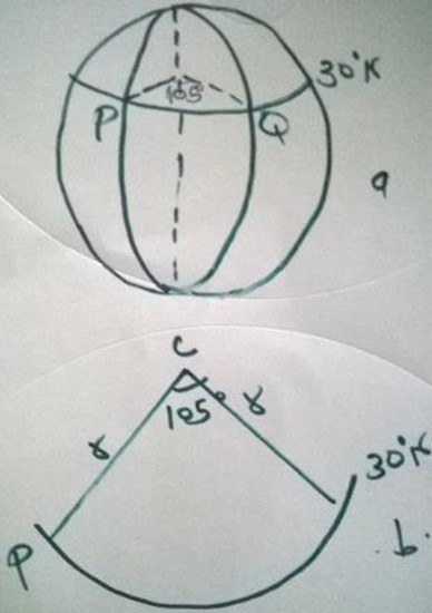
In general, if the angle at the centre of a circle of latitude is θ, then the length of its arc is 60 × r × θ, where θ is the angle between the longitudes along the same latitude.
Shortest distance between two points on the earth’s surface
The shortest distance between two points on the earth’s surface is that along a great circle.
Example
P and Q are two points on latitude φ. They lie on longitude λ1 and λ2 respectively. Find the distance from P to Q:
- Along a parallel of latitude
- Along a great circle
Solution
The positions of P and Q on earth’s surface are as shown below:
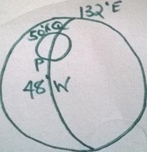
- The length of the circle parallel of latitude is 2πr km, which is 2πR cos φ. The difference in longitude between P and Q is Δλ.
PQ = (2πR cos φ) × (Δλ / 360)
- The required great circle passes via the North Pole. Therefore, the angle subtended at the centre by the arc PNQ is 180° – 2φ × Δλ.
Therefore the arc PNQ = R × θ = R × (180° – 2φ × Δλ)
Note:
Notice that the distance between two points on the earth’s surface along a great circle is shorter than the distance between them along a small circle.
Longitude and Time
The earth rotates through 360° about its axis every 24 hours in west–east direction. Therefore, for every change in longitude there is a corresponding change in time of 4 minutes, or there is a difference of 1 hour between two meridians apart.
All places in the same meridian have the same local time. Local time at Greenwich is called Greenwich Mean Time (GMT).
All meridians to the west of Greenwich Meridian have sunrise after the meridian and their local times are behind GMT.
All meridians to the east of Greenwich Meridian have sunrise before the meridian and their local times are ahead of GMT. Since the earth rotates from west to east, any point P is ahead in time of another point Q if P is east of Q on the earth’s surface.
Example
Find the local time in Nairobi (1°S, 37°E), when the local time of Mandera (3°N, 41°E) is 3.00 pm.
Solution
The difference in longitude between Mandera and Nairobi is 41° – 37° = 4°, that is Mandera is east of Nairobi. Therefore their local time differ by 4 × 4 = 16 minutes.
Since Nairobi is west of Mandera, we subtract 16 minutes from 3.00 p.m. This gives local time for Nairobi as 2.44 p.m.
Example
If the local time of London (0°, 0°) is 12.00 noon, find the local time of Nairobi (1°S, 37°E).
Solution
Difference in longitude is 37°.
So the difference in time is 4 × 37 = 148 minutes = 2 hours 28 minutes.
Therefore, local time of Nairobi is 2 hours 28 minutes ahead of that of London, that is, 2:28 p.m.
Example
If the local time of point A (170°E) is 12.30 a.m. on Monday, find the local time of a point B (170°W).
Solution
Difference in longitude between A and B is 340°.
In time, this is 4 × 340 = 1360 minutes = 22 hours 40 minutes.
Therefore local time in point B is 22 hours 40 minutes behind Monday 12:30 a.m., that is, Sunday 1:50 a.m.
Speed
A speed of 1 nautical mile per hour is called a knot. This unit of speed is used by airmen and sailors.
Example
A ship leaves Mombasa (4°S, 39°E) and sails due east for 98 hours to a point K in the Indian Ocean. Calculate its average speed in:
- Km/h
- Knots
Solution
- The length x of the arc from Mombasa to the point K in the ocean is:
x = r × θ (in degrees)
= 6370 × θ km
Therefore speed is distance/time = x / 98 km/h.
- The length x of the arc from Mombasa to the point K in the ocean in nautical miles is:
Therefore, speed = distance/time = x / 98 knots = 25.04 knots.
End of topic
Did you understand everything? If not, ask a teacher, friends or anybody and make sure you understand before going to sleep! |
Past KCSE Questions on the topic
- An aeroplane flies from point A (1°15’S, 37°E) to a point B directly North of A. The arc AB subtends an angle of 45° at the center of the earth. From B, the aeroplane flies due west to a point C on longitude 23°W.
(Take the value of π as 22/7 and radius of the earth as 6370 km)
- (i) Find the latitude of B
- (ii) Find the distance traveled by the aeroplane between B and C
- (a) The distance between the two towns in:
- Kilometers (take the radius of the earth as 6371 km)
- Nautical miles (take 1 nautical mile to be 1.85 km)
- (a) Find the distance covered by the plane
- (b) The plane then flies due east to a point C, 2400 km from B. Determine the position of C
Take the value of π as 22/7 and radius of the earth as 6370 km.
- (a) Calculate the distance covered by the plane, in nautical miles
- (b) After a 15 minutes stopover at B, the plane flew west to an airport C (30°N, 13°E) at the same speed.
- Calculate the total time to complete the journey from airport C, through airport B.
- When it’s 8 am at A, the time at B is 11.00 am.
- (a) Given that the longitude of A is 15°E, find the longitude of B.
- (b) A plane leaves A for B and takes 3½ hours to arrive at B traveling along a parallel of latitude at 850 km/h. Find:
- The radius of the circle of latitude on which towns A and B lie.
- The latitude of the two towns (take radius of the earth to be 6371 km).
Find, to the nearest degree, the latitude on which A and B lie.
- (i) Over the North Pole
- (ii) Along the parallel of latitude 30°N


