PHYSICAL GEOGRAPHY 1.4 – WATER MASSES
1.1 GROUND WATER
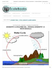
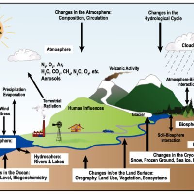
WATER CYCLE:
- Rain falls on the earth’s surface and infiltrates (soaks into) the soil.
- Some water flows over the surface as overland flow (runoff).
- Some water lies on the surface as ponds and lakes, and some return to the atmosphere as water vapour through evaporation and transpiration.
Factors enhancing the water cycle
- Nature of the soil and parent rocks.
- Steepness of the slopes.
- Nature of climate – It is a continuous succession of movement, condensation, evaporation, runoff, percolation, and precipitation.
- Water vapour is carried by wind to the land where it is deposited as rain or snow.
- Movement of water and water vapour form a system called the water cycle.

GROUND WATER (phreatic/subterranean H2O)
- Is the concentration of water within the ground surface. Water that sinks into the ground.
- The water exists within the interior of the earth’s crust. The water within the ground surface is contained in the pore space of the soil. A body of water derived from percolation contained in the soil, subsoil, and underlying rocks above impermeable layers.
SOURCES OF GROUND WATER
There are three main sources:
- Rain formation
Is the source of groundwater which exists during the formation of rainfall. It provides about 90% of the total water. - Rock formation
During the formation of rocks, water is formed with the element of water. The common rocks are sedimentary and igneous rocks. - Water bodies
Water bodies like oceans, seas, and rivers influence the development of groundwater. The water penetrates from the water bodies.
TYPES OF GROUND WATER
Groundwater is categorized according to its sources:
- Meteoric water
- Juvenile water
- Connate water
- Oceanic water
1. METEORIC WATER:
- Is the underground water formed due to the influence of rain formation. Rainfall is the only source of meteoric water (precipitation).
- This type of H2O is re-circulated, leading to the hydrologic cycle.
2. JUVENILE WATER
- Is the groundwater influenced by igneous rocks during their formation, which contain the element of water.
- Most juvenile water contains many minerals like fluoride and is also superheated water (hot spring).
3. CONNATE WATER
- Is the groundwater formed after the formation of sedimentary rocks, containing water trapped during rock formation (cold spring).
- H2O is usually salty and originates from ancient seas.
4. OCEANIC WATER
- Is the groundwater formed from water bodies. Their sources are rivers, lakes, and ocean water penetrating from these bodies.
METHODS OF OBTAINING GROUND WATER
- Percolation
Is the rapid penetration of water within the ground surface. This occurs when there are joints, cracks, or faults on the land surface. - Infiltration/filtration
Is the slow penetration of water within the ground surface. The water penetrates through natural spaces (pore spaces).
FACTORS AFFECTING GROUND WATER
These factors influence the variation of groundwater. The common factors are:
- CLIMATIC CONDITION
- In desert areas, there is poor concentration of groundwater due to increased evaporation caused by high temperatures.
- In equatorial and tropical regions, there is high concentration of groundwater due to heavy rainfall.
- RELIEF / ANGLE OF SLOPE
- Is the actual appearance of the landscape.
- In steep-sided areas, there is low concentration of groundwater since the water moves quickly down the slope.
- In gentle slopes (plains), there is a large concentration of groundwater (free penetration of water) since the speed of water decreases.
- NUMBER OF WATER BODIES
- Examples include lakes, oceans, rivers.
- Availability of water bodies increases groundwater availability.
- AMOUNT OF VEGETATION COVER
- Presence of vegetation promotes groundwater availability since vegetation helps in the formation of rainfall.
- Absence of vegetation leads to reduced groundwater availability.
- NATURE/PERMEABILITY OF ROCKS
- Permeable rocks allow free penetration of water downward.
- Impermeable rocks do not allow free movement/penetration of water.
- Primary permeability (porosity) results from open texture and pores.
- Secondary permeability results from joints and cracks.
SATURATION ZONE
These are layers within the ground surface that contain water. These zones can be permanent or seasonal.
TYPES OF SATURATION ZONE
- Non-saturated zone
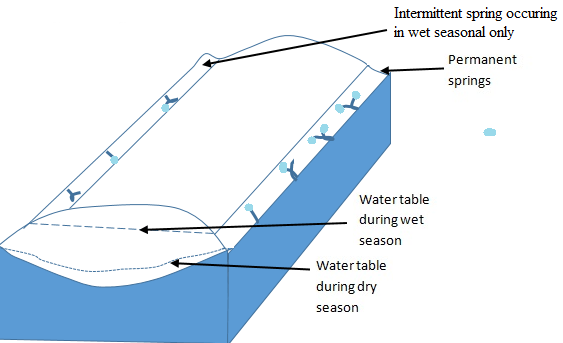
Is the part within the ground surface which does not contain water. It is the layer immediately below the surface. It allows H2O to pass through. - Seasonal saturated zone
Is the part within the ground surface which contains water periodically. This layer lies immediately below the non-saturated zone. Also known as intermittent saturation. This layer can dry out after a period of drought. - Permanent saturated zone
Is the part within the ground surface which is covered with water throughout. This layer extends as far down as the impermeable layer, forming the limit to downward percolation. - Impermeable rocks
Are rocks that do not allow free penetration of water.

1. NON-SATURATED ZONE
Is the part within the ground surface which does not contain water. It is the layer immediately below the surface. It allows H2O to pass through.
2. SEASONAL SATURATED ZONE
Is the part within the ground surface which contains water periodically. This layer lies immediately below the non-saturated zone. Also known as intermittent saturation. This layer can dry out after a period of drought.
3. PERMANENT SATURATED ZONE
Is the part within the ground surface which is covered with water throughout. This layer extends as far down as the impermeable layer, forming the limit to downward percolation.
AQUIFER/TABLE – Is the bed which allows water to pass through it and is underlain by an impermeable stratum (rock) forming a water-holding layer.
AQUICLUDE – Rock mass/layer that prevents the movement of groundwater.
4. IMPERMEABLE ROCKS
Are rocks that do not allow free penetration of water.
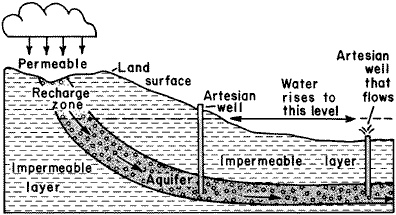
A. ARTESIAN BASIN
Is the position on the ground surface/landscape which contains water. This shows the existence of groundwater.
An artesian basin consists of a layer of permeable rock lying between two layers of impermeable rocks.
Conditions for presence of artesian well
- Climate condition – Rainfall availability.
- Angle of the slope – Depression/gentle sided.
- Amount of vegetation cover should be available.
- Presence of water bodies.
- Presence of a layer of permeable rock lying between two impermeable rocks.
B. WELL
Is a hole/hollow sunk in the ground up to below the water table. This can be either natural or man-made.
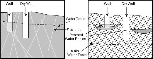
C. ARTESIAN WELL
Is a position on the land surface showing the existence of a well.
These wells tap water from artesian basins.
When the well is sunk into the basin, the hydrostatic pressure in the ground forces water to come out. If the water doesn’t reach the surface, it is known as a semi-artesian well.
Conditions for development of permanent well
- Climate condition – Summer season to know the dry season water table.
- Angle of the slope – Gentle slope.
- Amount of vegetation cover should be available.
- Water bodies available.
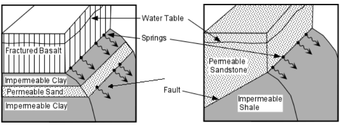
D. SPRINGS
- Is the outflow of water from the ground surface.
- Springs develop where the water table meets the surface.
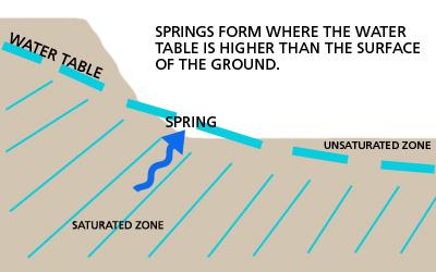
Conditions for development of spring
- The presence of enough groundwater.
- The presence of depression on the landscape.
- The water table should lie near the earth’s surface.
- The presence of soft rock and cracks on the landscape allowing free penetration of water.
- Permeable rocks should lie on impermeable rocks.
- The presence of internal pressure. This forces the outflow of water. Internal pressure is influenced by earth compaction.
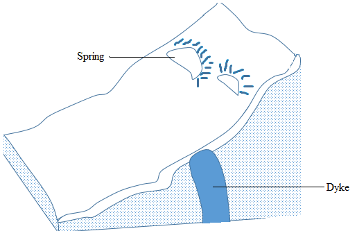
Ways in which springs can be formed (types)
Springs can occur where the rocks are well jointed; water enters the rock via joints. Springs frequently occur where the water table meets the surface.
The impounding of water by a dyke whereby it cuts across the layer of permeable rock causes water on the upslope side of the dyke to be impounded. The water table rises and gives rise to springs where it meets the surface.


HOT SPRING
- Is the outflow of superheated water from the ground surface; this involves heated water.
- The hot spring develops from juvenile water (groundwater forced during the formation of igneous rocks).
CONDITIONS
- Refer to the conditions of springs.
- The heat and pressure within the interior of the earth’s crust.
Importance/Effect of groundwater
- Water from wells may be used for irrigation in dry areas such as the Sahara; agriculture is practiced around the oases.
- Springs form a major source of water for both domestic and industrial use.
- Sites of settlement in many regions of the world.
- Formation of hot springs and geysers in areas with volcanic influence, likely to be a tourist attraction.
- Water for cattle ranches, e.g., Kansas in North America.
- Influence landslides.
- Destruction of minerals.
- Reappearance at a new site.
- Karst processes and resulting landforms.
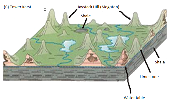
KARST SCENERY
Karst is the landscape formed from the dissolution of soluble rocks including limestone, dolomite, and gypsum.
Rainwater becomes acidic as it comes in contact with carbon dioxide in the atmosphere and the soil. As it drains into fractures in the rock, the water begins to dissolve the rock, creating a network of passages. Over time, water flowing through the network continues to enlarge the passages.
Chemical equation:
CaCO3 + CO2 + H2O → Ca(HCO3)2
Karst Topography
A form of landform denudation based almost exclusively on carbonation (chemical weathering).
Factors for the formation of karst regions
- The outcrop should be hard, porous, and well jointed.
- The climate of the area should be humid, e.g., temperate regions.
- The water table should be deep enough to allow percolation of water.
Major characteristics of karst scenery
- Absence of surface drainage.
- Outcrop of bare, rugged rock and steep-sided dry valleys.
- Numerous solution depressions and residual hills of various sizes.
- A subterranean network of caverns and watercourses.
- Joints are at right angles to each other.
LIMESTONE
Is a rock consisting of at least 80% calcium carbonate. It is a well-jointed rock, and its joints and bedding planes become opened up by rainwater that falls on its surface. It is an organic sedimentary rock formed by remains of tiny shells and micro-skeletons deposited on the seabed.
Carboniferous limestone
- Formed from the remains of organic matter, usually sea shells, plants, and coral.
Characteristics of carboniferous limestone
- It is a hard sedimentary rock with a large number of joints (vertical cracks) and bedding planes (horizontal planes).
- Main processes which affect it are carbonation and solution.
Landforms in Karst region
The landforms in Karst regions are divided into two:
- Surface features
- Subterranean/underground features
1. SURFACE FEATURES
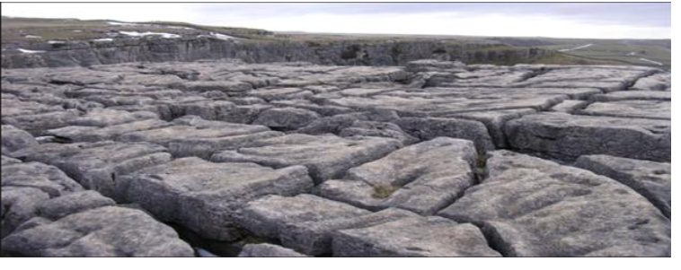
- Limestone pavement
Is a bare rock surface criss-crossed by numerous gullies where solution has worked along the joints – these are areas of exposed limestone.

Example of limestone pavement
Grikes
Are deep irregular grooves (gullies) formed when water erodes the cracks while running on the surface before disappearing underground.
Clints
Are ridges/blocks on the limestone rock separating the grikes.
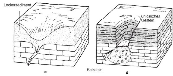
Swallow holes (sink holes)
This is a vertical hole leading to an underground cave system produced when the joints are enlarged by water percolating into the rock. The running water may sink down through the swallow hole.

Doline
Is a shallow depression/hollow with gently sloping sides and generally circular or oval in plan.
- They originate from water percolating underground at the intersection of major joints.
- When swallow holes join together, they form a large depression called a doline.
Uvala
Is a large closed depression with diameter generally greater than 500m. It is formed by coalescence/joining of several dolines. The floor is often hummocky consisting of several interconnected hollows.
Polje
This is a very large/shallow steep-sided depression with a generally flat floor.
- It may be many kilometers in size. The flat floor is often emphasized by the deposition of Terra rossa, a red clay material which forms an impermeable layer and leads to flooding after heavy rains.
- It is a very large depression formed when several uvalas collapse. The collapse can be due to faulting. Some poljes even have small lakes.

Dry valley
Is a valley with no permanent stream and often with steep almost vertical sides.
Most are caused by gradual lowering of the water table which itself is often due to the entrenchment of major streams into the limestone. As the water table falls, small streams become intermittent first and finally vanish.
Limestone gorge
This is a deep steep-sided valley formed by a large river with its headwaters beyond the limestone area steadily entrenching itself into the land surface. The steep cross profile is partly a result of the nature of rock jointing, formed when the roof of a cave collapses inwards. E.g., Cheddar Gorge.

Resurgence
Here the surface drainage reappears.

SUBTERRANEAN FEATURES:
These are features formed below the surface.
Limestone caves and caverns
- These are underground chambers formed due to solution of the limestone rock underground.
- First, a tunnel is formed, followed by the enlargement of the chamber or cave. Subsequently, due to further solution, a larger cave forms a cavern, e.g., Ambon caves in Tanga.

Stalactites:
- These are finger-like masses of calcite hanging vertically from the roof of the cavern. They are formed through deposition of drops of water containing calcium bicarbonate which have passed through crevices/joints.
- Calcite is deposited through evaporation and when carbon dioxide is released from water.

Stalagmites:
- Are stumpy rock masses which grow from the floor of the cavern upward. They are much thicker than stalactites. They crystallize on the floor and grow slowly but steadily towards the roof.
Natural pillar
This is the natural column or pillar formed either when the stalactites and stalagmites join or when the stalagmites grow to the point of reaching the roof.

Examples of Karst regions in the world
- Karst region in Yugoslavia.
- Causses region in southwest France.
- Kentucky Plateau in U.S.A.
- Ambon – Tanga.
- DRC.
- Morocco – Atlas region.
- Madagascar.
Economic importance of karst regions:
- Used as tourist attractions, hence bringing foreign currency to the country, e.g., Ambon caves in Tanga.
- Karstified limestone acts as an aquifer where water can be stored underground and later extracted by humans, e.g., in Texas.
- Creates complex underground water flow networks and large caves accessible to humans.
- Limestone is an important rock used in building and for making cement, e.g., Sokoto, Ewekoro in Nigeria.
- Sufficient pasture to support goats, sheep, and cattle but not good for cultivation since the soil is poor.
1.2 LAKES
A lake is a hollow which varies in size. Some lakes are natural and others are temporary.
A lake is a hollow filled with water coming from natural sources. A lake can be in liquid or solid form (glaciers) and can consist of fresh water or salt water. A lake can be formed from different natural forces and is named after that force together with its size.
The sources of water in the lake are from:
- On the surface (e.g., runoff, ice melting).
- Underground sources (e.g., karst region).
- From the atmosphere (rainfall).
CLASSIFICATION OF LAKES
Lakes are classified according to different criteria as follows:
- Due to earth movement, lakes can be formed from folding, warping (especially downwarping), and faulting.
- Due to erosion, lakes can be formed by wind and glaciation.
- Due to deposition, lakes can be formed due to oxbow and delta.
- Due to volcanicity, lakes can be formed due to crater, lava blocked, and lava subsidence.
- Others are formed due to solution lakes, mining, ponds, and dams.
EARTH MOVEMENT
Folding:
Folding lakes can be formed due to compression force. In young rocks with large pieces of rock, subsidence occurs or downwarping.

In old rocks, enough force leads to the formation of lakes in synclines.

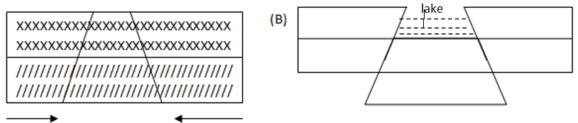
Faulting:
Lakes can be caused by faulting when tension force dominates.
Examples of folding and downwarping lakes include:
Lake Victoria, Lake Chad, Lake Eyre (Australia), Lake Titicaca (Peru).
Examples of lakes formed due to faulting are Lake Tanganyika, Lake Baikal (the deepest) in Russia, Lake Nyasa, Dead Sea, and Loch Ness in Scotland.
2. EROSION
There are lakes which are formed due to erosion, especially by wind and glaciation.
By wind:
Blocks of rock are dragged by strong winds, leading to the creation of depressions (oases). This leads to the creation of lakes especially when the depression reaches the water table.
When the depression reaches the water table and is exposed to the surface, it creates lakes and sometimes underground streams can be opened.
Wind can also form playas. Playas are holes which are dragged by the wind. They are dry and sometimes can contain fresh water or salty water.
By Glaciation:
Lakes can be formed by glacier erosion when avalanches move from the highlands and are deposited on the lowland, especially when they meet an obstacle and are prevented. In this sense, they may form glacier lakes or, in melting, form fresh lakes. They are called basin rocks, especially when they meet an obstacle. Examples include Lake Teleki – Cirque (corrie) lake, trough lakes (ribbon lake or finger lake).
Sometimes glaciers can erode the surface and cause elongated depressions where, after ice melts, they form lakes known as ribbon lakes. This happens when the ice erodes through the flat surface by accelerating (friction).
With glaciation, three types of lakes can be formed:
- Trough (ribbon) elongated feature.
- Rock basin.
- Corrie/Tarn/Cirque.
3. DEPOSITION
Delta lake:
A delta lake can be formed by a river. When the water erodes the sides of the banks, it forms deposition on the sides. Then ahead, the stream may be blocked due to erosion and create a lake.
4. VOLCANICITY
Crater:
This is formed after the eruption of molten material and creates a crater lake. Sometimes a second eruption can take place and lead to the formation of caldera lakes.
Lava Dammed Lakes:
These lakes are formed when a river stream is blocked by highly viscous lava that erupts and runs across the river. When lava cools and solidifies, it forms a dam behind which water collects to form a lake. Example: Kigezi in Uganda.


2 Comments