
5.10 RIVER BASIN DEVELOPMENT
River development projects are schemes developed for various purposes. They are called multipurpose schemes because they aim to meet many goals such as flood control, water supply for industries, irrigation schemes, settlement, and more. Examples of river development projects in Africa include the Volta River project in Ghana at Akosombo Dam, Orange River projects in South Africa, Gezira irrigation scheme in Sudan at Sennar Dam, Aswan High Dam in Egypt located on the Nile, Mwea, Tebere, and Galole irrigation schemes in Kenya, Rufiji Basin development, Kilombero Basin development, and Kagera development river basin development schemes. Outside Africa, examples include the Tennessee Valley projects, Indus in Pakistan, Ganges project in India, and Amazon Basin development scheme in Brazil.
Processes in River Basin Development
- Construction of dams for retaining water.
- Dredging of the river, which refers to the removal of silt or mud from the river.
- Straightening and widening of the river channel to accommodate more water.
- Clearing of vegetation where economic activities are to take place.
- Planting trees on the sides of the river to prevent soil erosion and reduce surface runoff, thereby reducing or preventing flooding.
- Creating canals and installing pipes to assist in irrigation.
Economic Importance (Benefits) of River Development Projects
- They help control floods where established.
- They improve navigation in the rivers, especially when dams are constructed.
- They lead to the development of the fishing industry, especially after dam construction.
- Water is provided for domestic use and industrial purposes.
- Water is supplied for irrigation schemes, leading to farm expansion and increased agricultural production.
- They serve as research centers for studying ecosystems and their importance to humans.
- River projects encourage environmental conservation, such as controlling soil erosion by planting trees.
- They have encouraged the development of towns; for example, in Germany, towns like Cologne, Bonn, and Frankfurt are found along rivers, helping to solve overpopulation problems.
- Employment is created in river basin development projects.
- They are centers for hydroelectric power generation.
- Silt removed during dredging adds fertility to the soil, promoting farming.
- They lead to the development of the timber industry; for example, in Canada and Sweden, rivers are used to transport timber downstream to sawmills.
Setbacks (Hindrances or Limitations) Facing River Basin Development Projects
- Unreliable rainfall and excessive evaporation cause drying of rivers and water bodies, hindering economic activities.
- Accumulation of silt in dams reduces water volume.
- Water pollution, especially from industries, discourages utilization of river basin water for economic development.
- Lack of capital for establishing and maintaining river basin projects.
- Lack of technological equipment and skilled labor for managing projects.
- Soil exhaustion due to intensive farming.
- Outbreaks of diseases like malaria and cholera.
- Displacement of people to other areas.
- Soil erosion can damage established projects.
Disadvantages of River Basin Development Projects
These disadvantages arise from problems caused by the schemes themselves. They include:
- Projects increase debt crises in developing countries due to borrowing from developed countries.
- Projects can cause soil erosion if not well managed.
- They cause environmental pollution such as increased soil salinity (salinization), acidification from chemical use in agriculture, industrial waste disposal, and air pollution from gases like methane and carbon monoxide.
- Construction of dams leads to displacement of people, causing disturbance and loss during migration.
- Projects are expensive to establish and consume large amounts of capital.
- They can lead to outbreaks of diseases affecting people.
- They can cause overpopulation as many people are attracted to settle near the projects.
- Conflicts may occur between countries sharing the river.
CASE STUDIES
TENNESSEE RIVER VALLEY DEVELOPMENT
The Tennessee River is a tributary of the Ohio River in the United States of America (USA). The Ohio River is a tributary of the Mississippi River. The Tennessee Valley receives high rainfall over 1250 mm, and in high areas, it can be as high as 2000 mm. The valley was characterized by fertile soil, attracting people who cleared vegetation for cultivation. Formerly, the river had an irregular flow and a huge silt load, making navigation difficult. It used to flood, and other problems included rapids and diseases. Poor cultivation methods led to erosion and a decline in agriculture. The valley is well known worldwide for successfully controlling severe soil erosion.
How the Valley Was Developed
The U.S. government organized the development of the valley by setting up the Tennessee Valley Authority (TVA) in 1933. The general aim was to solve the economic problems of the people.
Major Aims of the Scheme
- To control soil erosion and improve the quality of degraded land.
- To control floods.
- To improve navigation.
- To develop hydroelectric power generation centers.
Steps Taken by the Tennessee Valley Authority (TVA) in Developing the Valley
- Constructing 32 dams along the river course to control floods.
- Reforestation, especially on the steep slopes of the Appalachian Mountains.
- Filling gullies with brushwood to trap eroded soil particles, especially silt.
- Introducing modern farming methods such as terracing, contour ploughing, and crop rotation on slopes.
- Planting grass or cover crops on slopes to reduce surface runoff.
Advantages (Results) of the Project
- Increased water supply for irrigation, domestic, and industrial use.
- Improved navigation in the Tennessee River, with commercial freight ships operating.
- Hydroelectric power made available to many people.
- Floods have been highly controlled.
- Provision of hydroelectric power has led to the development of manufacturing and heavy industries, e.g., machinery and aluminum smelting in Alabama and Atlanta in Georgia, atomic power station and aluminum smelting at Alcoa.
- Stimulated development of mining, forestry, and related sectors.
- Created job opportunities for more than 50,000 people.
- Tourism developed with around 100 public parks and camping areas established.
- Erosion was highly controlled.
- Disease control improved, e.g., malaria.
- Increase in arable land size due to soil control.
- Development of the fishing industry due to dam construction.
Problems That Limit the Development of Such Schemes in the Country
- Political suspicion and terrorism.
- High establishment and running costs.
- Low government commitment toward developing such schemes.
- High rate of migration to urban areas, causing labor supply problems.
ST. LAWRENCE RIVER, USA
The St. Lawrence River drains the Great Lakes, flowing into the Atlantic Ocean. It passes through the most densely populated part of Canada and the highly industrialized portion of the USA. It serves as a waterway for ships for about 3,218 km and produces much hydroelectric power at Niagara and Cornwall. The St. Lawrence lowlands are good for agriculture due to fertile soil and a conducive climate with a long growing season and well-distributed rainfall. However, the river has many rapids and waterfalls.
These problems were solved by constructing canals to bypass the rapids and falls, such as the Erie and Welland Canals. Dredging and dam construction regulate river flow. The aim was to make St. Lawrence a seaway. The idea was opposed by railway companies in the US and took a long time to achieve. After signing the Canadian-American agreement in 1950, the St. Lawrence Seaway was opened in 1959.
Advantages
- Provides a good channel for bulk transport of wheat, iron ore, and coal.
- Encourages power supply due to fuel transport and hydroelectric power stations after dam construction.
- Stimulates growth of industries, especially timber, as forests provide raw materials and the river provides transport.
- Agriculture has developed, involving mixed farming and dairying due to good climate and fertile soil. Crops include wheat, maize, tobacco, potatoes, vegetables like lettuce, and fruits like apples.
The major limitation of navigation in the St. Lawrence River basin is winter freezing, which lowers river efficiency. This problem is reduced through systematic ice flow reporting and helicopter monitoring.
Note: Despite many drawbacks, St. Lawrence has not been a great financial success, with winter being the major hindrance.
Problems Due to River Basin Development
- Conflict with railway companies, as river basin development challenged the railway system.
- Industrial problems such as decline of some industries due to emergence of new ones; mining exhaustion caused migration and unemployment.
- Encroachment on rural areas, swallowing valuable agricultural land.
- Population increase leading to disease outbreaks and stench from dumping places in the river basin.
- Influx of people leading to ghetto life.
- Mining and timber industries, especially coal mining, have led to land degradation, deforestation, and erosion.
- New laws have been made to restore mined areas, but problems persist due to high coal demand caused by the global energy crisis.
THE RHINE RIVER BASIN IN EUROPE
The Rhine River flows through Switzerland, Germany, and the Netherlands and forms the border of France. It flows into the Atlantic Ocean, with most of its course in Germany. It is the most important river in Europe.
Characteristics of the River
- Low seasonal fluctuation; it seldom floods and rarely freezes.
- High volume due to many tributaries like the Moselle.
- Flows through highly industrialized areas.
- Fertile soil in the river basin.
- Navigable as far as Basel, 950 km upstream and 230 m above sea level.
- Freedom of movement along most of the Rhine course encouraged improved navigation along tributaries such as Main, Moselle, Neckar, and Ruhr.
- High water volume facilitates easy vessel movement.
- The river has been improved by straightening and dredging.
- Its ideal position and flow through the industrial heart of Germany make it intensively used as a commercial waterway for bulky goods and raw materials.
- Canals such as the Rhine-Rhone Canal, Main-Danube Canal, Albert Canal, Dortmund-Ems Canal, and Mittelland Canal link the Rhine waterway system, enabling barges with capacities exceeding 1,000 tonnes.
Importance of the Rhine River to Europe
- Stimulated development of hydroelectric power generation centers supplying power to industries, mining centers, and homes.
- Provides an outlet to the Atlantic Ocean from the interior of Western Europe.
- Led to industrial development; many industries in West Germany are located near the Rhine. Industrial towns include Ludwigshafen, Strasbourg, Stuttgart, Basel, Antwerp, Lyon, and Mainz.
- Supplies water for agriculture, market gardening, dairy farming, domestic, and industrial use, encouraging market gardening.
- Navigation has stimulated trade development, becoming an axis for trade in the European Common Market.
- Tourist attraction due to successful river water use for development.
- Stimulated growth of towns as people settle close to the river due to water availability.
Problems
- Spread of diseases due to water pollution caused by river basin development.
- Land degradation due to dense population; governments encourage population control.
- Aging population may lead to inefficient use of the river and its resources.
RIVER BASINS IN CHINA
China’s river basins have been the backbone of the country’s development. Rivers include the Huang He, Yangtze, and Si Kiang. Huang He and Yangtze originate from the Tibetan Plateau and flow into the China Sea. These basins offer fertile soil suitable for agriculture. Planned agriculture has been carried out in these basins.
How the River Basins Were Developed into a More Productive State
- The government launched comprehensive national schemes to control the great rivers Huang He, Yangtze, and Si Kiang, aiming for reclamation and creating navigable waterways.
- Several dams were constructed across river channels to hold back excess water during rainy seasons and minimize floods. The dams were multipurpose, encouraging navigation, providing water for domestic and industrial use, and supporting freshwater fishing.
- Canals were constructed to connect the great rivers, making transport cheap and efficient.
- Forestation programs were introduced to control soil erosion and provide products for economic and social use.
- Use of fertilizers and manure for land reclamation; deep ploughing was applied across slopes.
These initiatives were part of the twelve-year plan launched by the Chinese government, with people involved in decision-making and implementation.
Achievements as a Result of River Basin Development in China
- More arable land was reclaimed and used for agriculture and settlements.
- Industrial development took place, including metal engineering, chemical processing, and cement industries. Industrial centers in the Yangtze basin include Hunan, Chongqing, Guiyang, and Kunming.
- Growth of developed towns like Tianjin, Shanghai, and Chongqing.
- Stimulation of the mining sector due to transport development; minerals like coal and iron ore are mined.
- Greater supply of hydroelectric power due to dam construction.
- Floods have been minimized significantly after dam construction and tree planting.
Problems Caused by the Scheme
- High population growth causing stress on land and resources; the government has imposed strict population control policies.
- Water pollution due to domestic refuse and industrial waste, some of which are toxic.
- Land use expansion for agriculture and industry accelerates river floods.
Problems Facing the Scheme
- Disease and pests affecting crops, animals, and people.
- Frequent floods and storms affecting the river basin and activities.
- Land fragmentation due to high population pressure.
THE ORANGE RIVER BASIN DEVELOPMENT
The Orange River and its tributaries—the Harts, the Vaal, the Modder, and the Caledon—rise from the Drakensberg and flow westwards into the Atlantic Ocean. The river crosses or drains Lesotho, Botswana, South West Africa, and the Republic of South Africa. It is the largest river in South Africa, with a flow equal to all other rivers in the country combined.
Features of the River
- Carries a lot of silt due to unstable soil in South Africa.
- Tends to flood in the rainy season.
- Has high water fluctuation due to high evaporation, as it flows through the arid desert. Sometimes the river dries up, especially in the western parts.
The combination of aridity and poor water supply has made the western parts lag behind in development compared to the eastern part. However, the Orange River basin has high economic potential to support the increasing population due to:
- Wide valley allowing large-scale agricultural activities.
- Flat land surface suitable for irrigation schemes and mechanization.
- Fertile soil supporting a variety of crops.
The Orange River Basin Scheme
The project started in 1962 with the following objectives:
- To fully utilize the irrigation and hydroelectric power potential of the river and provide a sound basis for agricultural and industrial development.
- To control floods hindering river basin development.
- To achieve soil stabilization by planting trees.
The total cost was estimated at US $900 million, enabling irrigation of an additional 280,000 hectares.
The Process of Developing the River Basin
- Building dams such as the P.K. Le Roux Dam, Hendrik Verwoerd Dam (completed in June 1971), Mortimer, Kalkfontein, and Welbedacht. The dams provide water for irrigation, domestic use, industrial activities, and fishing.
- Construction of canals like Van der Kloof from P.K. Le Roux Dam to De Aar, Riet, Brak, Angers, and Carnarvon valleys for irrigation. Other canals lead to the Great Fish River, which has fertile soil but poor water supply.
- Channels and tunnels were constructed to lead water to drier parts for irrigation.
Achievements of the Orange River Scheme
- Increased irrigation area, leading to a 25% increase in crop production. Crops grown include wheat, maize, hay, groundnuts, cotton, and vegetables. Drought dangers have been minimized.
- Wide flood control reducing water damage.
- Reduction in silting through soil stabilization.
- Water supply stabilized due to dam construction, relieving existing water systems and increasing crop production.
- Stimulation of primary and secondary industries, e.g., textile industries developed due to improved sheep farming.
- More settlement areas established, attracting population from the east and reducing overpopulation.
- Reduction of imbalance between the west and east.
- Cheap power from dams has aided mining and communication development.
Problems Caused by the Scheme
- High government costs in establishment, potentially neglecting other economic activities.
- Dam construction accelerated coastal erosion.
- Water pollution leading to disease occurrence.
Problems Facing the Scheme
- Labor shortage due to migration to mining, manufacturing, and tourist areas. Ongoing tensions from apartheid cause labor availability problems.
- Diseases affecting crops, animals, and people reduce production efficiency.
- Soil erosion and silting due to unstable soil.
- Water availability under high competition among agriculture, mining, and industry.
- Volume fluctuation due to low rainfall and aridity in western parts.
THE KAGERA RIVER BASIN DEVELOPMENT PROJECT
Historical Background
The project was initially organized by the governments of Tanzania, Rwanda, and Burundi in 1977; Uganda joined in 1981. The main aim was to start a massive hydroelectric power scheme centered on a dam at Rusumo Falls on the Kagera River. Tanzania proposed building a 139.5-meter-high dam capable of generating at least 128 megawatts of hydroelectric power for large-scale industrialization and electrification of the Lake region. In May 1981, the four countries agreed to build a 132.5-meter-high dam at Rusumo Falls to produce 80 megawatts of hydroelectric power.
Characteristics of the Kagera River Basin
- Reliable water flow due to high rainfall in the highlands.
- Wide variety of plants and animals.
- Fertile soil suitable for agriculture.
- Some mineral deposits like iron, which can speed up mineral extraction.
Requirements for Establishing the Scheme
- Capital investment for equipment.
- Training of people to equip them with necessary skills for river basin development.
- Rwanda and Burundi needed new agricultural land due to displacement; Rwanda to lose about 8,200 hectares and resettle 10,500 families; Burundi to lose 3,200 hectares and resettle 1,600 families. This caused hesitation and disputes over compensation.
- Surveys to find new farmland for displaced people.
- Arranging claims and resolving disputes over new settlement sites.
- Ensuring availability of building materials.
- Common agreement among the countries concerned, as the project affects all.
Advantages Expected from the Kagera River Basin Development Project
- Production of hydroelectric power for member and neighboring countries.
- Employment opportunities.
- Development of transport and communication systems.
- Greater cooperation among member countries, promoting trade and peace.
- Development of agriculture and mining industries.
- Expansion and improvement of markets for crops produced.
- Development of the tourist industry.
- Improvement of living standards by electrifying the Lake Victoria region.
- Development of research activities, especially on biodiversity.
Problems Encountered in the Development
- Hesitation by Rwanda and Burundi over land loss.
- Lengthy research and preliminary planning.
- Decline of smaller projects due to government focus on this project.
- High expenses and insufficient government capital.
- Low technology levels requiring intensive training.
- Congestion issues as one project completes and another begins.
- Ongoing civil wars in Rwanda and Burundi causing insecurity and development delays.
- Labor supply problems due to migration to urban and mining centers.
THE RUFIJI RIVER BASIN DEVELOPMENT – TANZANIA
The Rufiji River in Tanzania is an example of an area with high economic potential but underpopulated because its resources can support more people.
Characteristics of the Rufiji River Basin
- Largest river in Tanzania, originating from southern interior highlands and emptying into the Indian Ocean.
- Features waterfalls, meanders, alluvial fans, and oxbow lakes.
- Variety of animal and plant life, including mangroves and grasses.
- Resources include water, oil, natural gas, wildlife, and good arable land.
- Conducive climate with enough rainfall and high temperatures supporting diverse crops.
- Tends to flood in the rainy season, causing transport problems and property destruction.
Activities Going on in the Rufiji Basin
- Small-scale fishing by local inhabitants; a proposed prawn farming project faced environmental resistance.
- Cultivation of rice, sugarcane, coconuts, vegetables; large-scale irrigation in the Kilombero River basin.
- Tourism in Selous Game Reserve, contributing foreign currency.
- Hunting of wild game by locals.
- Lumbering involving locals and businessmen from other regions.
- Research and mineral exploration ongoing.
Why the Rufiji Basin Has High Economic Potential
- Large fertile land not fully utilized for agriculture, which could boost the economy.
- Attractive features like vegetation variety, delta, oxbow lakes, meanders, alluvial fans, animals, fish, and birds, attracting tourists.
- Potential resources for power production like waterfalls, oil, and gas deposits, some idle or underexploited.
- Enough rain and good temperature supporting crops like rice, sugarcane, beans, and maize.
- Available labor for transforming the basin into a productive area.
Factors Limiting Development of the Rufiji Basin
- Poor capital availability for investment.
- Low technology levels; locals use poor tools.
- Labor shortage due to rural-urban migration.
- Remoteness with poor transport and communication systems.
- Poor market availability; locals have low purchasing power due to poverty.
- Government priorities focused elsewhere.
- Frequent floods damaging crops and property.
What Should Be Done?
- Improve local technology to facilitate resource exploitation.
- Seek financial assistance from donors for capital investment.
- Restrict rural-urban migration by investing in the region and establishing projects.
- Improve transport and communication systems for better movement of people, information, and products.
- Intensify environmental conservation to enhance local attractions and draw visitors.
- Implement water conservation to promote supply for domestic, industrial, and irrigation use.
Threats to the Rufiji Basin Development
The basin faces threats such as water pollution, deforestation, diseases, land degradation, resource exhaustion, and conflicts. Causes include tourism, fishing, agriculture, lumbering, fuelwood extraction, mining, and settlement.
KILOMBERO IRRIGATION SCHEME (TANZANIA)
Located along the Kilombero River (a tributary of the Rufiji River) in southern Tanzania, near the Great Ruaha River. Water is pumped to supply overhead sprinkler irrigation.
Organization of the Scheme
Large sugar estates and factories are at Msolwa and Ruembe. Small-scale farmers, called outgrowers, were allowed to cultivate 6,000 hectares to ensure sufficient sugarcane supply. Agricultural facilities and extension services were provided. Three settlement villages were established about 20 km south of the company estates. Initially, European expatriates managed the scheme, later replaced by local Tanzanians.
Aim of the Scheme
- To open up the remote and less prosperous southern Tanzania.
- To improve sugarcane yields; about 2,800 hectares are irrigated. Other crops include rice, beans, maize, and vegetables. Fishing also takes place.
Factors That Facilitated the Development of the Scheme
- Need to develop rural southern Tanzania.
- Availability of large fertile land in the river basin.
- Reliable water supply from the river.
- High demand for sugar.
- Availability of transport services, e.g., TAZARA railway line.
Advantages of the Scheme
- Flood control, turning the river into a resource rather than a hazard.
- Stimulated development and maintenance of railways and roads.
- Increased sugar production compared to earlier scarce and expensive supplies.
- Reduced dependency on imported sugar, saving foreign currency.
- Opened remote areas like Msolwa and Ifakara by encouraging road and railway construction.
- Created employment opportunities.
- Improved living standards of outgrowers through training and assistance.
- Developed markets and new towns like Kidatu, Makambako, and Mikumi offering social services.
- Provided expert advice to farmers, encouraging technology development.
- Promoted market for hydroelectric power from Kidatu.
- Developed timber and fishing industries.
Problems Facing the Scheme
- Poor labor supply due to rural-urban migration.
- Diseases like cholera and malaria affecting farmers.
- Climatic problems like drought reducing water availability.
- Poor transport infrastructure; roads and bridges are inadequate, limiting access during wet seasons.
Prospects of the Project
The government intends to develop the valley further by:
- Constructing more dams to retain water year-round.
- Maintaining and upgrading roads.
- Training locals in diversified economic activities beyond sugar production, such as fishing, timber production, wildlife conservation, and mining.
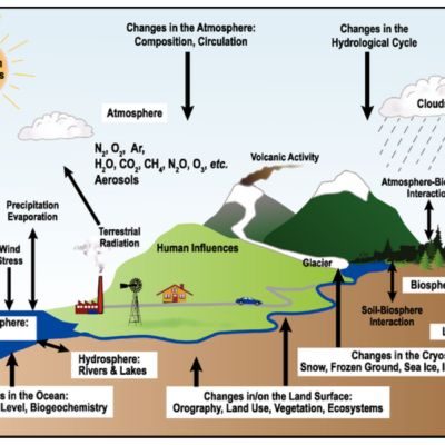
Importance of Rivers, Dams, and Lakes
- Generation of hydroelectric power (e.g., Kihansi on Kilombero River, Mtera and Kidatu on Great Ruaha, Nyumba ya Mungu on Pangani River, Kariba Dam).
- Promotion of transport and communication.
- Supply of water for irrigation, domestic, and industrial uses.
- Modification of the environment by introducing moisture to the atmosphere, leading to rainfall formation.
- Attraction of settlements due to water supply and fertile soil.
- Tourism attraction due to features like waterfalls.
- Rivers act as boundaries (e.g., Ruvuma between Tanzania and Mozambique, Kagera between Tanzania, Rwanda, and Uganda).
- Promotion of the fishing industry.
Problems of Rivers, Dams, and Lakes
- Fluctuation of river volume due to excessive evaporation.
- Problems of cataracts, rapids, and waterfalls hindering navigation.
- Invasion of vegetation in water bodies affecting fishing and navigation.
- Short river courses limiting water availability for economic uses.
- Some rivers drain water away from areas needing irrigation, emptying into the ocean.
- Water bodies can spread diseases like bilharzia.
- Conflicts arise when rivers are shared by many countries (e.g., Nile, Ruvuma, Kagera).
- Flooding causes property destruction, soil erosion, and disease spread.
REVISION QUESTIONS
- What are the advantages of river basin development schemes?
- Mention five disadvantages of river basin development schemes in Africa.
- Mention six river basin development schemes in Africa.
- What is the basic requirement for developing a river basin development scheme?
- Mention the factors that facilitated the development of the Punjab Agricultural Scheme in the Indus River basin.
- Outline the factors that hinder the development of river basin schemes in Tanzania.
- Mention the problems caused by river development schemes in any country you have discussed.
- Identify the advantages of the following river basin development schemes:
- (a) The Kagera River Basin International Development Scheme.
- (b) The Kilombero River Basin Development Scheme.
- Show five achievements the Tennessee Valley Authority (TVA) attained in developing the Tennessee Valley.
- Explain four benefits smallholder farmers get from the Kilombero River Basin Development Scheme.


7 Comments