

FORM 2 GEOGRAPHY
INTERNAL LAND FORMING/ENDOGENETIC PROCESSES
Processes operating in the interior of the earth resulting in the formation of natural physical features or landforms.
They are caused by earth movements.
Examples of these processes are folding, faulting, and vulcanicity.
Formation of landforms by internal land forming processes is determined by:
- Nature and age of earth materials
- Type of movement involved
- Intensity and scale of movement involved
Crustal Earth Movements
Displacement of the earth’s crustal rocks.
They are brought about by tectonic forces which originate and operate in the interior of the earth, e.g., tensional forces (which operate along horizontal planes moving away from each other), compressional forces (which operate along horizontal planes moving towards each other), shear forces (which move past each other with unequal strength), and gravitational forces (which attract things to the earth’s centre).
Earth movements are of 2 types:
- Horizontal/lateral/orogenic movements
- Vertical/epeirogenic movements
Horizontal Earth Movements
Movements which act along a horizontal plane within crustal rocks.
They are caused by tensional, compressional, and shear forces.
Effects
They cause:
- Strain and stretching of crustal rocks due to tensional forces which cause formation of cracks or faults.
- Squeezing and shortening of crustal rocks by compressional forces which also cause formation of faults.
- Crustal rocks to shear by slipping past each other or by dividing into layers, caused by shear forces.
Results of Horizontal Earth Movements
Results in the formation of the following features:
- Faults
- Rift valleys
- Fold mountains
- Escarpments
- Basins
- Tilt blocks
- Block mountains
Vertical Earth Movements
Movements which occur along the earth’s radius or towards the earth’s surface or towards its centre.
Effects
Causes:
- Subsiding/sinking/downwarping or pulling of crustal rocks downwards.
- Uplifting/upwarping or pushing of crustal rocks upwards.
- Tilting of crustal rocks or shearing in vertical direction due to greater uplift on one side.
Results of Vertical Earth Movements
- Raised cliffs
- Tilt blocks
- Rift valleys
- Fault scarps/escarpments
- Plateaus
- Basins
Causes of Earth Movements
- Magma movement within the earth’s crust.
- Gravitational force.
- Convectional currents in the mantle.
- Isostatic adjustment.
Magma Movement within the Earth’s Crust
- When magma moves with force pushing crustal rocks horizontally or vertically.
- When magma moves from reservoir and leaves empty spaces onto which crustal rocks are pulled inwards.
Gravitational Force
When the attractive force of the earth pulls crustal rocks into empty spaces left after magma escaping from the reservoir.
Convectional Currents within Mantle

When convectional currents in magma in mantle drag crustal rocks by friction.
Horizontal movement of currents causes horizontal movements while vertical causes vertical movements.
Isostatic Adjustment
Rising of continental masses to restore the upset state of balance between sial and sima layers.
Isostacy is the state of balance between sial and sima layers.
It can be disturbed by erosion on continents and melting of continental ice sheets.
The reduced weight causes continental masses to rise.
(skip 8 lines for diagram KLB bk 2 pg2) fig 1.3
Theories Explaining the Earth’s Movements
A theory is reasoned ideas intended to explain facts or ideas.
There are 2 theories which explain the earth’s movements namely the Continental Drift Theory and the Plate Tectonics Theory.
i) Theory of Continental Drift
Its proponent was A. Wegener.
It explains the origin of 6 continents.
It states:
- The earth was a single sialic land mass called Pangaea surrounded by a huge ocean called Panthalasa whose floor was a mass of sima.
- Pangaea broke into two parts called Laurasia (N. Hemisphere) which lay around equator and Gondwanaland (S. Hemisphere) which lay around south pole, separated by a narrow ocean called Tethys (the present Mediterranean Sea).
- Laurasia broke into Laurentian Shield and Fennoscandia (Europe, Asia and N. America) and moved northwards to their present positions.
- Gondwanaland broke into Africa, Australia, S. America, Antarctica, and India subcontinent.
- Africa and India drifted northwards.
Evidences Supporting the Theory
- Fitting of western coast of Africa and S. America into a jigsaw.
- Discovery of coal at 40°N and 55°N which was formed by burying of tropical vegetation.
- Considerable displacement of rocks along some faults e.g., along the Great Glen Fault of Scotland.
- Cape and Buenos Aires folds resemble one another by having east-west trend.
- Red sea shores show evidence of having undergone lateral displacement, an indication that it was formed by movement of the earth’s crust.
- Evidence of ancient glaciation to the south of equator in Africa, Madagascar, and India where there is presence of ancient glacial deposits suggesting these areas were once around south pole.
ii) Plate Tectonics Theory
It states that:
- The earth’s crust is made of blocks called plates.
7 Large Ones
- Eurasian plate
- Australian plate
- Africa plate
- Antarctic plate
- N. American plate
- S. American plate
- Pacific plate
Smaller Ones
- Indian
- Arabian
- Caribbean
- Cocos
- Somali plates
- Juan de Fuca
- Nazca
- Philippine
- Scotia
- These plates are two types: tectonic plates:
- Oceanic plates which form major areas of the ocean floor including coastal lowland.
- Continental plates which form the bulk of the continental land mass.
- The plates float on molten mantle layer called Asthenosphere.
- The plates move relative to each other due to convectional currents in the mantle.
- They move away from each other forming extension or constructive boundary called so because magma fills the space between.

- They move towards each other forming compressional or destructive boundary called so because materials between are crushed. The movements of those two types of plates have the following effects:
- When two oceanic plates meet

- There is subduction and the ocean floor is pulled inwards forming a trench e.g., Java Trench. Subduction is the passing of edge of one plate beneath the edge of another.
- Sediments on the sea floor in the region of subduction are compressed to form Fold Mountains.
- When an oceanic plate meets a continental plate, the edge of the oceanic plate slides beneath the continental plate in a movement called subduction.
- Sediments on the sea floor in the region of subduction are compressed to form Fold Mountains.
- Fold Mountains are also formed at the edge of the continent when the sial layer is compressed.
- The edge of the oceanic plate bends into the mantle forming a trench.
- When two continental plates collide, the sial layer is folded into mountains.


- They move past each other forming transform or conservative boundary called so because there is neither construction nor destruction which occurs where the plates are separated by a major fault.

Significance of Plate Movements
- Are sources of earthquakes and vulcanicity.
- Cause formation of landforms such as Fold Mountains and ocean trenches.
- Spectacular landscapes formed are a tourist attraction.
- Eruption of magma can result in formation of valuable minerals.
FOLDING
Process in which crustal rocks are distorted by compressional forces by being caused to bend upwards and downwards.
It occurs on fairly young sedimentary rocks.
Parts of a Fold

- Anticlines (upfolds) – parts of the earth’s surface which bend upwards when folding occurs.
- Synclines (downfolds) – parts of the earth’s surface which bend downwards when folding occurs.
- Crest – uppermost part of Anticline.
- Trough – lowest part of a syncline.
- Limb – rock layers sloping on both sides of a fold.
- Axis – imaginary line drawn vertically through the centre of the anticline.
Types of Folds
1. Simple Symmetrical Folds

Which are symmetrical about the anticline.
Formed by 2 compressional forces of equal magnitude.
2. Asymmetrical Folds
Which are asymmetrical about the anticline’s axis or in which one limb is steeper than the other.
Formed by two compressional forces of unequal magnitude in which one is stronger than the other.

3. Over Folds

In which anticline of one fold is pushed over the limb of the other.
4. Isoclinal Folds

Which are packed closely together and with limbs almost parallel to each other.
Vertical Isoclinal folds are formed by compressional forces of equal magnitude while inclined Isoclinal folds are formed by forces of unequal magnitude.
5. Recumbent Folds

Which lie in a horizontal manner.
Formed by two compressional forces one of which is very strong.
6. Nappe/Overthrust Fold

In which one limb is pushed over the other limb.
The forces are very strong and they cause a fracture/fault to develop.
7. Anticlinorium and Synclinorium Complex
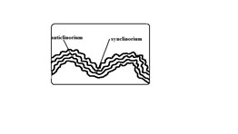
Folds characterised by minor upfolds and minor downfolds.
- Land is first subjected to weak compressional forces resulting in minor folds.
- Later the land is subjected to much greater compressional forces resulting into new upfolds with minor folds (Anticlinorium) and new downfolds with minor folds (Synclinorium).
Resultant Features Due To Folding
1. Fold Mountains and Their Distribution
World’s highest and most impressive mountains and the most conspicuous feature of folding.
- Himalayas – Asia
- Everest – Nepal-Tibet border – highest point.
- Andes – Peru in S. America
- Alps – South Central Europe
- Rockies – W.N. America
- Atlas – N.W. Africa
- Appalachian – E.N. America
Theories of Origin of Fold Mountains
1. Contraction Theory
During the earth’s formation surface rocks cooled faster and wrinkled to form Fold Mountains.
2. Convectional Currents Theory
- Horizontal convectional currents in the mantle exerted frictional pull on crustal rocks.
- Continental crusts were pulled towards each other.
- Sediments between them were squeezed into folds.
3. Continental Drift Theory
- During break of Gondwanaland India drifted northwards and collided with Eurasia.
- Sediments between were squeezed to form fold mountains e.g., Himalayas and Everest.
4. Plate Tectonics Theory
- When an oceanic plate meets another or it meets a continental plate the sediments under the sea are compressed to form Fold Mountains.
- When two continental plates meet the sial layer is compressed to form fold mountains.
E.g., Alps was formed when Africa plate pushed against the rigid European plate.
2. Escarpments

A relatively continuous line of steep slopes facing the same direction.
Formed when compressional force causes folding resulting in one steep limb of the anticline which forms the escarpment.
3. Depressions

Formed when not very strong forces cause folding causing some parts of the earth’s surface to form synclines forming basins.
4. Ridges and Valleys

When folding occurs anticlines form uplands/ridges/hills while synclines form valleys.
5. Rolling Plains

Plains which appear to rise and roll.
Formed when plains are acted upon by weak compressional forces resulting into gently sloping anticlines and very wide synclines.
6. Inter-montane Plateaus

A high fairly level land between mountains.
Formed when rocks at the edges of a region become intensely folded and the middle parts resist folding resulting into mountains which enclose a high fairly level land.
7. Inter-montane Basins
Formed when some parts of inter-montane plateau sink more to form basins.
Significance of Folding
To Human Activities/Economic Significance
Positive/Advantages
- Fold Mountains are a tourist attraction which brings foreign exchange.
- Fold Mountains are water catchment areas and sources of rivers.
- Some fold mountains have valuable mineral deposits such as coal and petroleum.
- Fold Mountains act as protective barriers during war.
- Some fold mountains on the path of rain-bearing winds influence rainfall causing the windward slopes to receive heavier rainfall.
- Folding can lead to formation of valuable minerals due to metamorphism.
- Folding brings valuable minerals to the surface making them easily available.
Negative/Disadvantages
- Fold Mountains on the path of rain winds cause the leeward slopes to receive less rainfall.
- Fold Mountains discourage settlement due to cold temperatures and rugged terrain.
- Folding can lead to burying of minerals.
- Fold Mountains are a barrier to road and railway where there are no passes and where there are passes they may be covered by snow. Orographic fog hinders pilot’s visibility.
To Physical Environment
- Folding can result in submerged coastal zones which are used as harbours.
- Can lead to metamorphism of rocks changing their original state and making them more resistant to erosion.
- Depressions formed by folding turn into wetlands important for water purification.
- Folding leads to faulting and magma may escape through faults leading to vulcanicity and earthquakes.
FAULTING
Faulting is the cracking/fracturing of the brittle crustal rocks due to tectonic forces.
Faults are fractures or cracks that develop in the crust.
- When tensional forces cause crustal rocks to stretch and fracture at the region of maximum tension.
- When compressional forces cause squeezing of crustal rocks to fracture at the areas where they are intensely squeezed.
- When vertical movements exert pressure on rocks leading to fracturing.
- When shear forces cause crustal rocks to tear.
Parts of a Fault

- Upthrow – part of the land displaced upwards.
- Downthrow – part of the land displaced downwards.
- Throw – vertical displacement.
- Heave – horizontal displacement.
- Hade – inclination of fault to vertical plane.
- Fault line – fault path.
- Fault plane – separation of land created by the fault.
Types of Faults
Normal Faults
Type formed by tensional forces in which one block slides downwards in relation to the other.
- Rocks are subjected to tensional forces.
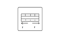
- A normal fault develops.

- One block slides downwards.

Reverse Fault
Type formed by compressional forces in which one block of land is pushed upwards in relation to the other.
- Rocks are subjected to compressional forces.

- A reverse fault develops.

- One block is pushed over the other.

Shear/Tear Fault
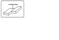
Type formed by shear forces in which adjacent blocks of land slide past one another. If a shear fault occurs between continents it’s called a Transform fault e.g., San Andreas fault of California and Great Glen fault of Scotland.
Thrust Faults

Type formed when very strong compressional forces cause almost horizontal faults to develop and one block of land is pushed over the other.
Anticlinal Fault

Type formed when anticlines are compressed further and cracks form on the crest.
Features Resulting From Faulting
Fault Scarp/Escarpment
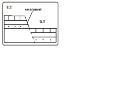
Steep line of slopes formed by vertical movement of earth along a fault e.g., Mau, Nguruman, Nyandarua, and Nandi.
Are exposed parts of a fault plane.
It may be formed due to normal faulting or reverse faulting when overhanging blocks are eroded.
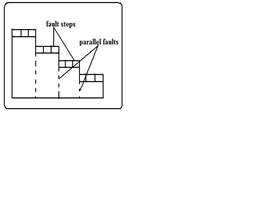
Fault Steps
Land resembling the staircase or steps of a house with a series of fault scarps at different levels.
- Parallel vertical faults develop.
- Land between the faults is unequally displaced downwards.
- A series of fault scarps at different levels is formed.
E.g., Keiyo escarpment and at Kijabe.
Fault Blocks/Block/Horst Mountains
Blocks of land raised above the surrounding land.

Where tectonic forces cause faulting and land on one side of the fault get raised or sink along the fault planes.
Examples of fault blocks are Aberdare/Nyandarua ranges, Mau escarpment, and Nandi Hills.

- Where blocks of land bordered by normal faults which are almost parallel to each other sink leaving the middle block standing.
Examples of horsts are Ruwenzori of W. Uganda and Usambara and Pare mountains of Tanzania.
Tilt Blocks
Fault blocks which are inclined on one side.
- Occurs when the fault block, horst or fault steps have greater uplift on one side and as a result they are not flat at the top but tilted. The resultant features are tilted fault blocks, tilted horst, and tilt fault steps which form ridges and fault guided valleys.


Rift Valley
Along narrow trough with steep escarpments on both sides.
Theories of Formation
Tensional Theory
- Rocks are subjected to tensional forces.

- Normal faults which are almost parallel develop.

- One block slides downwards forming the rift valley.

Compressional Theory
- Rocks are subjected to compressional forces.
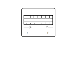
- Reverse faults which are almost parallel develop.

- The side blocks are pushed over the middle block.

- Overhanging blocks are worn out by denudation to form escarpments.

Anticlinal Theory
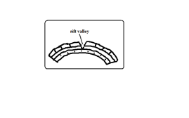
Suggests the rift valley was formed by Anticlinal arching.
- Upward forces pushed sedimentary rock strata upwards.
- The rock layers bent into a big arch.
- A gaping/huge crack developed at the crest of the arch due to tension forming the rift valley.
The Great Rift Valley/The Great E.A Rift Valley
The world’s biggest rift valley.
It starts in Syria and ends in Mozambique.
It’s divided into 4 parts.
- Ethiopian Rift system – starts from Afar in Ethiopia to the Kenyan border around L. Stephanie.
- Gregory Rift system – starts from the northern border of Kenya with Ethiopia to Tanzania. It has small N.E-S.W branches:
- Kano Rift valley in Kenya
- L. Eyasi Rift Valley in Tanzania
- Western Rift valley – starts at Sudan border to south of L. Rukwa. Features here are Ruwenzori Mountain and Lakes Albert, Edward, Kivu, Tanganyika, and Rukwa.
- Malawi Rift valley – a continuation of Gregory Rift system to Zambezi River in Mozambique. It has a small N.E-S.W branch called Luangwa valley.
The Gregory Rift Valley
Named after a geologist called Gregory J.W who carried out extensive studies in this area.
It’s where the Rift Valley features are more pronounced.
Features associated with it
- Fault blocks – Aberdare range, Mau, Nandi, and Cherangani hills.
- Step faults – Kijabe and Tambach.
- Tilt blocks – Aberdare range uplifted and tilted eastwards and Mau escarpment uplifted and tilted westwards.
- Lava flows and volcanic cones e.g., Menengai and Ngorongoro crater.
- Rift Valley lakes formed when unequal sinking created faults which were later filled with water. The lakes are deep and elongated. Examples are Lakes Naivasha, Nakuru, Elementaita, Baringo, Bogoria, Ol Bolossat, and Turkana. Most of the lakes are salty except L. Naivasha which has fresh water.
Why Most Rift Valley Lakes Are Salty
- Lack of outlets to drain away salts contained in them.
- Lack of enough water to dilute salinity due to little rainfall and lack of rivers flowing in them.
- High rates of evaporation causing increased accumulation of salts.
- Lake’s water being in contact with rocks with mineral salts which it directly dissolves.
- Washing into the lake of mineral-rich soils by surface runoff.
Why L. Naivasha Has Fresh Water
- It has underground drainage to the Indian Ocean.
- There is inflow of fresh water from rivers and rain.
- The latest volcanic eruption covered the bedrock with lava.
Major Faulted Areas of the World
- The Great Rift Valley from Syria to Mozambique.
- Northern England and the Great Glen Fault of Scotland.
- The Central Massif of Europe.
- The middle Rhine Rift Valley region.
Significance of Faulting
To Human Activities
- Rift valley lakes are important for fishing, irrigation, and domestic use.
- The Rift Valley and associated features are a tourist attraction which earns foreign exchange.
- Hot springs and geysers formed during faulting can be harnessed for geothermal power.
- Block Mountains are water catchment areas and sources of rivers due to the heavy rainfall they receive on the windward side.
- Faulting results in the exposure of minerals such as diatomite in Gilgil and Fluorspar in Kerio Valley.
- Fault scarps may expose underground water resulting in the formation of scarp springs.
- Unequal subsidence caused by faulting may cause formation of depressions which may form lakes useful for fishing, transport, and mining e.g., L. Naivasha.
Negative
- Faulting disrupts transport and communication by disjointing land.
- Faulting may lead to loss of life and property by causing land to sink.
- Faulting may cause a river to disappear or change its course and flow along the fault line.
- Steep scarp slopes formed by faulting are prone to soil erosion.
- Faulting has given rise to semi-desert conditions in some areas when Block Mountains on the path of rain winds cause leeward sides to receive little rainfall.
VULCANICITY
Process in which solid, liquid, or gaseous materials are forced out of the interior of the earth into the earth’s crust or onto the earth’s surface.
These materials are magma, lava, gases, dust, ash, and cinder.
Causes of Vulcanicity
- Magma under high temperature and pressure moving through lines of weakness or faults.
- When tectonic plates move away from each other and boundaries give way to magma.
- Underground water coming into contact with hot materials hence changing into gaseous form.
There are 2 types of Vulcanicity:
Extrusive Vulcanicity (volcanic): in which materials intrude crustal rocks and don’t reach the earth’s surface. Magma is the molten material while it’s underground.
Intrusive Vulcanicity (plutonic): in which materials reach the earth’s surface. Lava is the molten material after it reaches the surface.
There are two types of lava and magma, acidic and basic. Acidic lava is viscous and solidifies quickly and doesn’t spread far but accumulates around the vent. Basic lava is more fluid or less viscous and takes longer before cooling and spreads for great distances before doing so. Other materials emitted are gases, ashes, dust, and cinder. The solid materials are called pyroclasts. Materials come out through a hole/vent (vent eruption) or crack/fissure (fissure eruption).
Features Resulting From Vulcanicity
Divided into intrusive and extrusive features or landforms.
Intrusive/Plutonic Features

Features formed by intrusive Vulcanicity when materials intrude the earth’s crust.
Sill
An igneous intrusion which lies along a bending plane of rock strata.
Formed when magma forces its way between rock layers then cools and solidifies.
It forms ridge-like escarpments when exposed by erosion e.g., Fouta Djalon highland of Guinea and 3 sisters of S. Africa.
Dyke
A wall-like igneous intrusion which lies across the bedding plane of rock strata.
Formed when magma intrudes cracks or faults cutting across bedding planes of rocks then cools and solidifies.
Can be vertical or inclined.
When exposed it forms ridges e.g., Kaap Valley in Transvaal S. Africa and Jos Plateau in Nigeria.
Laccolith
A mushroom-shaped igneous intrusion lying between bending planes of a country rock.
Formed when viscous magma pushes its way through a vent and accumulates around the vent before reaching the earth’s surface pushing the overlying rock into a dome shape.
It’s so high that land is turned into mountains e.g., El Koub Hill in Algeria, Henry Mountains in Utah U.S.A, and Fonjay Massif in Madagascar.
Batholiths
Largest igneous intrusion formed underground formed when very hot magma intrudes bedding planes of rocks and replaces or metamorphoses it e.g., Chaila Massif in Gabon, Ikhonga-Murwe in Kakamega and the largest is in British Columbia.
Lopolith
A large saucer-shaped igneous intrusion formed when viscous magma intrudes into bedding planes of a country rock. They form shallow depressions on the earth’s surface e.g., Bushveld complex in S. Africa and Duluth Gabbro mass in U.S.A.
Phacolith

A lens-shaped igneous intrusion which forms in the crest or trough of an anticline e.g., Corndon Hill in England.
Extrusive/Volcanic Features
Formed when magma reaches the earth’s surface through vents or fissures.
Volcanoes
A volcano is a cone-shaped hill formed when volcanic materials flow out and accumulate around a vent. Volcanoes are classified into three groups:
- Active volcano – which is known to have erupted in recent times e.g., Ol Donyo Lengai in Tanzania, Mt. Cameroon, and Mauna Loa in Hawaii.
- Dormant volcano – not known to have erupted in the recent past but show signs of volcanic activity such as presence of hot springs, geysers, and fumaroles e.g., Mt. Kilimanjaro, Longonot, and Menengai.
- Extinct volcano – which has not shown signs of possible future eruptions e.g., Mountains Kenya and Elgon.
Types of Volcanoes
Acidic Lava Domes

- Viscous lava flows out through a vent.
- It accumulates around the vent because it’s viscous.
- Eruptions occur later and lava flows out covering the layers below.
- A steep-sided dome-shaped mound of volcano is formed e.g., Itasy Massif of Madagascar, Mt. Kenya, and Kilimanjaro.
Characteristics
- Its dome-shaped
- Has steep slopes
- Made of acidic lava
- Has lava layers
- Has a narrow base
Basic Lava Domes/Shield Volcanoes

- Basic magma flows out to the surface through a vent.
- The lava flows far before solidifying because it’s fluid.
- Eruptions occur later and lava spreads over the old lava.
- A shield-shaped mound of volcano is formed e.g., Canary Islands, Cape Verde, and Sao Tome which are volcanic Islands in the Indian Ocean.
Characteristics
- Dome/shield shaped
- Has gentle slopes
- Made of basic lava
- Has lava layers
- Has a broad base
Ash and Cinder Cones

A volcano built from ash and cinder or small fragments of lava.
- Violent vent eruption occurs.
- Ash and pyroclasts are emitted and thrown high.
- Some materials fall and settle around the vent forming a hill.
- Light materials are blown by wind to the leeward side e.g., Chyulu Hills, Teleki, and Likaiyu near L. Turkana.
Characteristics
- Made of pyroclasts
- Asymmetrical about the axis
- Cone shaped
- Has smooth slopes
- Has steep windward slope and gentle leeward slope
Composite /Complex/Stratified Volcanoes

A volcano made of alternating layers of lava and pyroclasts and conelets.
- The first eruption throws out pyroclasts.
- Then viscous lava flows out and solidifies on them.
- Eruption occurs later blowing the rocks sealing the vent.
- The pieces of rock settle on earlier solidified lava.
- Another mass of lava flows out and spreads over pyroclasts and solidifies.
- The process is repeated causing the volcano to build upwards.
- The conelets are formed when magma is unable to overcome the plug and finds its way through weak lines at the sides and then pyroclasts and lava accumulate around the side vent e.g., Mountains Kenya, Longonot, Elgon, and Kilimanjaro.
Characteristics
- Cone shaped
- Stratified (made of alternating layers of lava and pyroclasts)
- It has conelets (parasitic cones)
- It has steep slopes.
- Made of acidic lava
Plug Dome/Volcano/Spine

A column of very viscous lava which sticks above the ground.
- A column of very viscous magma flows out of the ground.
- It cools and hardens rapidly as it rises vertically.
- Pieces of rock break from the plug and accumulate on the sides e.g., Mont Pelee in West Indies, Hyrax and Fischer’s Tower at Hells Gate in Naivasha, and Devils Tower in U.S.A.
Characteristics
- Made of very viscous lava.
- It is dome shaped like a mushroom germinating out of the ground.
- Has debris on its sides.
- Has very steep sides.
- Cylindrical in shape.
- Disintegrates fast due to rocks undergoing rapid cooling.
Volcanic Plug

Stump of rock formed when magma which solidified inside a vent (plug) is exposed by denudation.
- A volcano is first formed.
- Lava on the sides of the volcano is eroded fast due to cooling fast.
- The lava in the vent which is hard due to slow cooling is exposed forming a stump of rock e.g., Peaks of Mt. Kenya, Rangwa Hill, and Tororo Rock.
Characteristics
- It resembles a stump of a tree.
- It’s dome shaped.
- Very steep at the top and less steep at the bottom.
- Made of hard/resistant rock.
Lava Plains and Plateaus

Lava plain: fairly level lowland below 500m above sea level covered by thin lava layers.
Lava plateau: fairly level highland/upland above 500m above sea level covered by thick layers.
Formed by fissure eruption.
- Magma of low viscosity comes out of the ground through a fissure.
- It flows for a long distance before cooling and solidifying filling depressions and valleys forming a plain.
- Eruption occurs later and lava flows out through lines of weakness on crustal rock and solidified lava.
- The new lava spreads on top of the old lava forming a new layer.
- The process is repeated and a plateau is formed e.g., Mwea, Nandi, and Laikipia Plains and Yatta and Uasin Gishu Plateaus.
Craters
A funnel-shaped depression found on top of a volcano.
Modes of Formation
Cooling and Contraction of Magma
- Eruption occurs and a volcano is formed.
- Magma in the vent cools and contracts.
- It withdraws into the vent leaving a depression at the vent’s mouth e.g., Ngorongoro and Menengai craters.
- Rainwater or water from melting snow may collect into craters to form crater lakes e.g., L. Paradise on Mt. Marsabit, L. Magadi on Ngorongoro Crater, and L. Chala on Kenyan-Tanzania border.
Explosion
- Gases underground expand due to heat from magma.
- They force their way out through a weak line in the crustal rocks.
- An explosion occurs leaving a hole in the ground called a ring crater e.g., Ghama and Dobot craters in Tanzania and Hora craters in Ethiopia.
- Water from underground or rivers may accumulate into ring craters to form lakes called maars e.g., Lakes Katwe and Nyungu in Uganda.
Falling of a Meteorite
- A meteorite falls on the earth’s surface.
- It sinks into the rocks leaving a depression.
- Water may collect into the depression forming a lake e.g., L. Bosumtwi in Ghana.
Calderas/Basal Wreck
A very large basin-shaped depression on the summit of a volcano.
Modes of Formation
Violent Explosion
- Gases and water heated by magma expand.
- They force their way through a vent.
- The rocks at the top of the volcano are blown off forming a large depression e.g., Nyirarongo Caldera in DRC and Sabiro Caldera in Uganda.
Block Subsidence/Cauldron

- Eruption occurs to form a volcano.
- An empty space (cauldron) is left in the magma reservoir in the mantle.
- The rocks forming the middle of volcano are pulled inwards by gravity.
- The middle of the volcano collapses forming a large depression at the top e.g., Menengai Caldera near Nakuru and Ngorongoro caldera which is the largest in E. Africa and 6th largest in the world.
- Water from rain or underground may fill calderas to form lakes e.g., L. Magadi in the Ngorongoro caldera and L. Ngozi in Tanzania.
Outward Collapsing
- Ash and pyroclasts volcano grows high.
- Materials on top exert pressure on those below.
- Materials at the base begin to spread outwards.
- The top of volcano collapses inwards forming a collapse caldera e.g., Napak Caldera in Uganda.
A vent in a volcano which emits gases.
Fumaroles
The gases come from chemical reactions in crustal rocks when heated by magma or when minerals in rocks come into contact with hot air and steam underground.
They are of two types:
Mofette: fumarole which emits carbon dioxide.
Solfatara: fumarole which emits gases with sulphurous compounds.
Hot Springs and Geysers
Hot spring is a place where hot water is emitted from the ground quietly e.g., at the shores of Lakes Magadi and Bogoria.
A geyser is a jet of water and steam which are violently ejected from the ground e.g., at Olkaria and western shores of L. Bogoria.
How They Are Formed
- Percolating water is heated by hot rocks or magma.
- Some collect into chambers called sumps where it develops pressure causing it to be superheated.
- The pressure forces the steam outwards towards the earth’s surface through holes and cracks in rocks.
- The steam comes out of the ground which reduces pressure in sumps causing the water to expand/boil and come to the surface.
- The steam comes out with a whistling sound accompanied by water forming a geyser.
- The escaping steam heats groundwater in surrounding rock.
- The heated water may find its way to the surface where it quietly comes out of the ground forming a hot spring.
Differences
| Hot spring | Geyser |
|---|---|
– Water comes out quietly. – Only water comes out. – Water may just be warm. | – Water and steam come out violently. – Water is accompanied by steam. – Water is very hot. |
Pools of Boiling Water
Small area of still water which appears to be boiling.
- Actual heating of pool water by gases and steam causing the water to boil.
- Gases and steam coming out below the pool of water causing the pool to bubble and appear as if it’s boiling.
World Distribution of Volcanoes
- Regions of faulting e.g., the Great Rift Valley of E. Africa.
- Mid-Atlantic ocean ridge.
- The western coast of America.
- Zones of recent mountain building e.g., fold mountains of S.E Asia.
Significance of Vulcanicity
Positive
- Volcanic rocks weather to form fertile agriculturally productive soils e.g., basalt.
- Geysers are sources of geothermal electricity e.g., at Olkaria.
- Hot springs water is pumped into houses for heating during winter e.g., Iceland.
- Volcanic features are a tourist attraction e.g., hot springs, geysers, and snow-capped Mt. Kenya.
- Igneous rocks e.g., phonolites are crushed to make ballast for building roads, bridges, etc.
- Crater lakes are a source of fish e.g., L. Katwe in Uganda, sources of minerals e.g., L. Magadi and sources of water for domestic use.
- Volcanic mountains are catchment areas, sources of rivers, and habitats for wildlife.
- Pumice, a volcanic rock, is used as a scrubbing stone.
- Vulcanicity is useful for production of gases e.g., carbon dioxide used in soft drinks manufacture.
Negative
- Volcanic eruptions cause loss of life and destruction of property e.g., sulphur dioxide, ash, cinder, and lava may bury houses and farmland.
- Volcanic mountains are barriers to transport and communication.
- Volcanic mountains on the path of rain winds cause leeward slopes to receive little rainfall by preventing rain-bearing winds from reaching there.
- Volcanic eruptions cause environmental pollution from dust, ash, and sulphur dioxide.
EARTHQUAKES

Sudden and rapid movement of the earth’s crust.
Areas prone to them are called seismic zones and those not prone are called aseismic zones.
It’s caused by shock waves.
There are 3 types of earthquake waves namely:
- Primary waves – which travel fastest and cause the rock particles to vibrate in a push and pull manner and can pass through gases, liquids, and solids.

- Secondary waves – which cause rock particles to vibrate at right angles to the direction of wave movement.

- Surface longitudinal waves – which cause surface rocks to shake sometimes causing buildings to collapse.
- Rayleigh waves – which cause surface rocks to move in elliptical orbits.

- Love waves – which cause rock particles to move in a horizontal manner at right angle to the direction of wave.

Earthquake originates from a point known as seismic focus/origin.
The part of the earth vertically above the seismic focus and where the shock waves are first experienced is called epicentre.
Causes of Earthquakes
Natural Causes
- Tectonic movements e.g., movement of tectonic plates. They cause tectonic earthquakes.
- Vulcanicity when magma movement displaces rocks suddenly shaking and shuttering them.
- Gravitational force when crustal rocks collapse into cauldron due to gravity.
- Energy release in the mantle when radioactivity takes place in mantle releasing explosive energy which sends shock waves outwards.
- Isostatic adjustment when the continental masses rise to restore the upset state of balance between sial and sima layers.
Human Causes
- Exploding nuclear bombs underground which causes shock waves which spread outwards and are felt in the neighbourhood.
- When a train rolls on its rails causing the ground to vibrate.
- Explosion of explosives used in mining and quarrying which cause vibrations to be felt in the neighbourhood.
- When large reservoirs are constructed and the heavy weight of water reactivates dormant faults causing tremors.
Measurement of Earthquakes
Seismograph is a pendulum-based instrument used to measure earthquakes.
It records seismic impulses on a graph-like record called seismogram mounted on it.
Earthquakes are measured by their intensity and magnitude.
Intensity
Measure of how strong/hard the quake shakes the ground.
It’s seen from the effects the earthquake has on people, buildings, and other structures.
It’s measured on the Mercalli Scale which uses a scale running from Roman i-xiii e.g.
- I – imperceptible
- V – rather strong – sleepers are awakened and there is swinging of objects.
- VIII – destructive – gaping cracks in walls some brought down.
- XII – major catastrophe – every building destroyed.
Magnitude
Measure of amount of energy given off by an earthquake.
It’s measured on Richter Scale which ranges from 0-8.9.
Intensity values depend on how far a place is from epicentre.
The higher the scale the more severe the earthquake is.
- Intensity I – magnitude 2
- Intensity VIII – magnitude 6
- Intensity XII – magnitude 8.5
World Distribution of Earthquakes
- Within the zones of major faulting e.g., Rift Valley.
- In areas of vulcanicity e.g., Oldonyo Lengai in Tanzania.
- Along boundaries of tectonic plates e.g., Japan, Philippines, East Indies, and west coast of North and South America.
Effects of Earthquakes
- Can cause loss of life and property when buildings collapse burying people.
- Disrupt transport and communication by vertically and laterally displacing land which disconnects pipelines, electricity lines, roads, and railways.
- Causes landslides which also cause loss of life and property and disrupts communication.
- Causes raising and lowering of the sea floor and the coastal regions.
- Cause huge sea waves called Tsunami which may flood the neighbouring coastal areas.
- Trigger folding, vulcanicity, and fires.
- Give off a lot of explosive energy more than an atomic bomb.
- Cause fear and panic.
- Hinder settlement as it is restricted to aseismic areas.
- Cause violent motions of the earth’s surface.


3 Comments